Application conditions are seldom perfect. In every situation, the applicator must be aware of the current and probable future weather conditions in order to make the best application decisions to prevent drift.
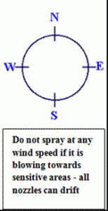
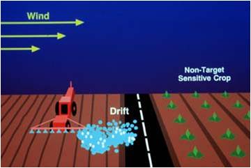
WindThe wind is one of the most common contributors to pesticide droplet drift. Pay attention to both wind speed and wind direction. Pesticide labels sometimes carry only general warnings about wind. In the absence of specific label directions, the wind speed should be AT LEAST 3 and NO MORE THAN 8 miles per hour blowing in a direction away from sensitive areas. Wind speeds above 8 mph substantially increase the risk of spray drift to downwind areas adjacent to the application site. Wind speeds below 3 mph are often variable and may change direction rapidly. Conditions with no wind may indicate a temperature inversion (see below), potentially allowing a concentrated cloud of very fine droplets to remain suspended and drift great distances. Monitor wind speed and direction frequently, take appropriate steps to manage drift, and stop the application if wind conditions become unfavorable.
|
 |
Temperature and Humidity
 Increasing temperature affects both vapor drift and droplet drift. Many pesticides evaporate at higher temperatures than water. On a hot dry day, this means that when the spray leaves the application equipment, the water may begin to evaporate from the spray droplet. This causes the droplet to become smaller and fall more slowly. The slower it falls, the greater the opportunity for more water to evaporate. At some point, a droplet becomes small enough to be carried from the application site in even a gentle wind. Although the droplet is smaller from the loss of water, it may still contain the same amount of pesticide as the original droplet. Some labels will specify the temperature and/or humidity requirement for using the product. An example would be “do not apply this product when temperatures exceed 85 degrees F or humidity is below 20%.” When making applications in hot dry conditions, consider adjusting application equipment to produce a larger droplet and reduce the height of the nozzles to the lowest recommended distance.
Temperature Inversions
 Under normal conditions during daylight hours, the warmest air is near the earth’s surface, and the temperature decreases with altitude. The sun warms the ground and crop canopy. This in turn warms the air above it. The warm air then rises and is replaced with cooler air from aloft causing a mixing action of the atmosphere. Winds that are generated often blow from a fairly consistent direction.
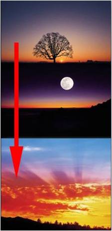
During a temperature inversion, this situation is reversed. From dusk to early morning, the earth’s surface can lose heat causing air near the surface to be cooler than the air above it. Because cool air sinks, the result is a stagnant layer of air that does not mix with air above it. Indications of temperature inversions include smoke that rises to a certain height and then moves sideways, dust hanging in the air behind a vehicle, fog hanging in low areas, or calm conditions with no winds.
Temperature inversions are favorable to long-distance pesticide drift. With the cool, humid conditions found during a temperature inversion, small droplets can remain suspended above the sprayed area for a long time. Just as morning fog slowly moves into lower elevations, the concentrated cloud of droplets can move downslope with the layer of cool air and cause damage or contamination for miles. Sloped areas are not the only concern during temperature inversions. As winds pick up, suspended droplets can be carried great distances from level
application sites as well.
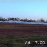
Winds during an inversion are often light, variable in direction, and very often influenced by topography. If you have a sensitive area near the application site, you have no control over which direction the wind may carry the droplets. In some parts of the country, significant temperature inversions are nearly an everyday occurrence.
When there is no wind, be alert to the possibility of an inversion. Do not spray within or above (aerial application) an inversion.
Initial compilation courtesy of Jim Wilson, PhD
![]()